


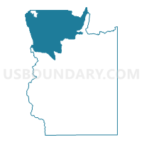
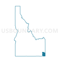
Georgetown Voting District, Bear Lake County, Idaho
About
Outline

Summary
| Unique Area Identifier | 563739 |
| Name | Georgetown Voting District |
| County | Bear Lake County |
| State | Idaho |
| Area (square miles) | 193.20 |
| Land Area (square miles) | 192.58 |
| Water Area (square miles) | 0.62 |
| % of Land Area | 99.68 |
| % of Water Area | 0.32 |
| Latitude of the Internal Point | 42.49774650 |
| Longtitude of the Internal Point | -111.45070650 |
Maps

Graphs
Select a template below for downloading or customizing gragh for Georgetown Voting District, Bear Lake County, Idaho


Neighbors
Neighoring Voting District (by Name) Neighboring Voting District on the Map
- Bailey Creek Voting District, Bear Lake County, ID
- Bennington Voting District, Bear Lake County, ID
- Bern Voting District, Bear Lake County, ID
- Grace 1 Voting District, Caribou County, ID
- Liberty Voting District, Bear Lake County, ID
- Soda 2 Voting District, Caribou County, ID
Top 10 Neighboring County Subdivision (by Population) Neighboring County Subdivision on the Map
- Soda Springs CCD, Caribou County, ID (3,907)
- Montpelier CCD, Bear Lake County, ID (3,439)
- Grace CCD, Caribou County, ID (2,007)
- Paris CCD, Bear Lake County, ID (1,729)
- Georgetown CCD, Bear Lake County, ID (818)
- Wayan CCD, Caribou County, ID (238)
Top 10 Neighboring Place (by Population) Neighboring Place on the Map
Top 10 Neighboring Unified School District (by Population) Neighboring Unified School District on the Map
- Bear Lake County School District 33, ID (5,835)
- Soda Springs Joint School District 150, ID (4,338)
- Grace Joint School District 148, ID (2,249)
Top 10 Neighboring State Legislative District Lower Chamber (by Population) Neighboring State Legislative District Lower Chamber on the Map
Top 10 Neighboring State Legislative District Upper Chamber (by Population) Neighboring State Legislative District Upper Chamber on the Map
Top 10 Neighboring 111th Congressional District (by Population) Neighboring 111th Congressional District on the Map
Top 10 Neighboring Census Tract (by Population) Neighboring Census Tract on the Map
- Census Tract 9601, Caribou County, ID (4,091)
- Census Tract 9501, Bear Lake County, ID (3,439)
- Census Tract 9602, Caribou County, ID (2,872)
- Census Tract 9502, Bear Lake County, ID (2,547)